Photo: Egerer
Today we are resorting to the multi-faceted nature park Sierningtal, close to Ternitz. Varied hiking trails for families and trained hikers and magnificent natural monuments are waiting
for us.
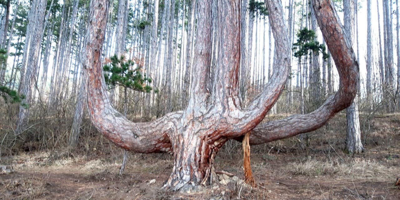
We start at the parking lot St. Johann am Steinfelde, at the church, where signposts show us where to enter nature park Sierningtal. Attention: We do not follow the path that sits above the parking lot at the church, but return to the street and follow the blue marking until we strike a forest path. We turn left and, after about ten minutes, arrive at the so-called “Sesserlbäume”. The trunks of five pine trees, formed by man, branch out about one meter above the ground. One tree even totals eight trunks.
Actual ascent
We then walk back the same path until we discover the blue marking that leads us uphill. Soon we arrive at a fork, turn left to “Hühnersteig” and follow the red marking direction Gösing. Nice steep-tracks through light pine wood and ever splendid views escort us. One finds the first lookout point at Schönbühel where one can catch sight of the glorious mountains of the Wechsel region. We move on, following the red marking uphill. Our trail crosses a forest path from time to time, yet we stay on our forest trail. After one and a half hours one traverses the last forest path before the summit cross, here a red marking is visible at right hand side, still we stay on the straight steep track, until we reach the highest point, Gösing, 898 meters. Benches and chairs for taking a break and enjoying a snack are waiting here for tired hikers.
Embarassment of riches
From there one can proceed to different directions. We follow the red marking direction Schneebergblick and Neunkirchnerhaus, estimated walking time 45 minutes. The second magnificent lookout point is the before-mentioned Schneebergblick. The rock faces around are also impressive. Another bench is waiting there, great view included.
We continue along the red marking until we encounter a forest road, forks and signposts. We turn right direction “Fleischesserföhre”, the second impressive natural monument, a pine tree of vast proportions. The eponym was a farmer called Fleischesser who owned the forest and died in 1945. We return to the forest path and continue until a nature studies path, marked in blue, detours to the left. This nature trail leads us back to the fork where we turned left onto Hühnersteig at the beginning of our tour.
We are on tour for three or three and a half hours and cover 460 meters difference in altitude. If you are looking for silence and loneliness, I recommend tackling this semidiurnal hike during the week, best early in the morning.
Maps of trails informing you about many other hiking options are available at municipality Ternitz.
Info
Dolores Marie Schärf unterrichtet Englisch, Französisch, Spanisch sowie Italienisch und ist als
Dolmetscherin bzw. Übersetzerin tätig.

Tip from the mountain security service
Dear leisure time sportsmen and sportswomen,
We have experienced a winter that brought a lot of snow. Days are getting longer and temperatures are opening the gates to spring. On the mountains, however, snowfields are going to linger for a few more weeks. It is vital to be particularly attentive when traversing these snowfields. They often possess a frozen surface, even during the day – this means extreme slip hazard. Please only cross these danger spots when using appropriate equipment (climbing spur or snow spikes). Slipping on a snowfield can easily end at a rocky scree. Especially crystalline spring snow can be as rough as coarse sand paper – which can lead to deep grazes. Best avoid these areas. Stay healthy!